You can save this article by registering for free here. Or sign-in if you have an account.
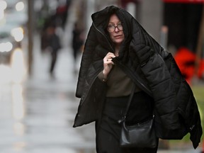
People were using coats, umbrellas or whatever they had to avoid the wet mix of rain and sleet in advance of the snowstorm expected Wednesday evening in downtown Ottawa.Photo by JULIE OLIVER /Postmedia
Article content
Winter is expected to provide what is hopefully a going away present for the capital region starting Wednesday.
Advertisement 2
Story continues below
This advertisement has not loaded yet, but your article continues below.
THIS CONTENT IS RESERVED FOR SUBSCRIBERS ONLY
Subscribe now to read the latest news in your city and across Canada.
Exclusive sports coverage by Bruce Garrioch, Ken Warren and Tim Baines, in-depth crime and news from Gary Dimmock and city life coverage from arts writers Lynn Saxberg and Peter Hum. Plus, daily newsletters and events.
Unlimited online access to Ottawa Sun and 15 news sites with one account.
Ottawa Sun ePaper, an electronic replica of the print edition to view on any device, share and comment on.
Daily puzzles, including the New York Times Crossword.
Support local journalism.
SUBSCRIBE TO UNLOCK MORE ARTICLES
Subscribe now to read the latest news in your city and across Canada.
Exclusive sports coverage by Bruce Garrioch, Ken Warren and Tim Baines, in-depth crime and news from Gary Dimmock and city life coverage from arts writers Lynn Saxberg and Peter Hum. Plus, daily newsletters and events.
Unlimited online access to Ottawa Sun and 15 news sites with one account.
Ottawa Sun ePaper, an electronic replica of the print edition to view on any device, share and comment on.
Daily puzzles, including the New York Times Crossword.
Support local journalism.
REGISTER / SIGN IN TO UNLOCK MORE ARTICLES
Create an account or sign in to continue with your reading experience.
Access articles from across Canada with one account.
Share your thoughts and join the conversation in the comments.
Travel warnings, rain and 20 to 30 cm of snow. Welcome to spring.Back to video
Environment Canada has issued a snowfall warning for the Ottawa region, as well as the Brockville, Leeds and Grenville area.
Article content
“Snowfall with total amounts of 15 to 20 cm is expected (Wednesday) into Thursday,” the agency said in a bulletin issued at 4:51 a.m.
The storm should begin with rain Wednesday morning, and “slowly transition to snow late in the day,” the warning said.
Snow is expected to continue through Wednesday night and taper off Thursday.
People were using coats, umbrellas or whatever they had to avoid the wet mix of rain and sleet in advance of the snowstorm expected Wednesday evening in downtown Ottawa.Photo by JULIE OLIVER /Postmedia
In a Wednesday afternoon memo, Scott Caldwell, Ottawa’s manager of parking services and public works, said the city will closely monitor the spring storm over the next 48 hours.
He said the city’s response will vary, depending on conditions, as “there remains uncertainty on the exact details of this spring storm.”
Advertisement 3
Story continues below
This advertisement has not loaded yet, but your article continues below.
Article content
“As the precipitation moves in, we will keep a close eye on sidewalks, roads, and the winter cycling network and deploy resources as needed,” Caldwell’s memo reads, adding that snow is expected to be wet and heavy as temperatures hover around freezing.
It was a rainy Wednesday afternoon in the Ottawa Market before the snow began to fall.Photo by Tony Caldwell /Postmedia
“Roads and Parking Services will continue to monitor this weather system and the transportation network throughout the evening and overnight,” he said.
As of Wednesday afternoon, the Chief William Commanda Bridge remained open, but the city will be monitoring conditions on the bridge closely, Caldwell said, and if conditions worsen, “it will be closed for the safety of pedestrians and cyclists.”
Forecasters warn that poor travel conditions are expected, especially Thursday morning.
Advertisement 4
Story continues below
This advertisement has not loaded yet, but your article continues below.
Article content
People were using coats, umbrellas or whatever they had to avoid the wet mix of rain and sleet in advance of the snowstorm expected Wednesday evening in downtown Ottawa.Photo by JULIE OLIVER /Postmedia
With temperatures hovering close to freezing, “the snow may be very heavy and wet in nature.”
“Rapidly accumulating snow could make travel difficult over some locations,” the agency said.
“Visibility may be suddenly reduced (and) highways, roads, walkways and parking lots may become difficult to navigate due to accumulating snow.
The weather front is expected to clear out Thursday night.
Snow flurries could continue Friday and sporadically over the weekend.
People were using coats, umbrellas or whatever they had to avoid the wet mix of rain and sleet in advance of the snowstorm expected Wednesday evening in downtown Ottawa.Photo by JULIE OLIVER /Postmedia
Our website is your destination for up-to-the-minute news, so make sure to bookmark our homepage andsign up for our newsletters so we can keep you informed.
Postmedia is committed to maintaining a lively but civil forum for discussion. Please keep comments relevant and respectful. Comments may take up to an hour to appear on the site. You will receive an email if there is a reply to your comment, an update to a thread you follow or if a user you follow comments. Visit our Community Guidelines for more information.
This website uses cookies to personalize your content (including ads), and allows us to analyze our traffic. Read more about cookies here. By continuing to use our site, you agree to our Terms of Service and Privacy Policy.


Postmedia is committed to maintaining a lively but civil forum for discussion. Please keep comments relevant and respectful. Comments may take up to an hour to appear on the site. You will receive an email if there is a reply to your comment, an update to a thread you follow or if a user you follow comments. Visit our Community Guidelines for more information.